പ്രമാണം:Map of downtown Rome during the Roman Empire large.png

ഈ പ്രിവ്യൂവിന്റെ വലിപ്പം: 800 × 566 പിക്സലുകൾ. മറ്റ് റെസലൂഷനുകൾ: 320 × 226 പിക്സലുകൾ | 640 × 452 പിക്സലുകൾ | 1,024 × 724 പിക്സലുകൾ | 1,099 × 777 പിക്സലുകൾ.
പൂർണ്ണ വലിപ്പം (1,099 × 777 പിക്സൽ, പ്രമാണത്തിന്റെ വലിപ്പം: 74 കെ.ബി., മൈം തരം: image/png)
| ഈ പ്രമാണം വിക്കിമീഡിയ കോമൺസിൽ നിന്നുള്ളതാണ്. പ്രമാണത്തെക്കുറിച്ചുള്ള വിവരണം താഴെ കൊടുത്തിരിക്കുന്നു.
|
| ഇത് ഒരു മിനുക്കിയെടുത്ത ചിത്രമാണ്, യഥാർത്ഥ പതിപ്പിൽ നിന്ന് ഡിജിറ്റലായി മാറ്റങ്ങൾ വരുത്തിയിട്ടുണ്ടെന്നാണ് ഇതിനർത്ഥം. മാറ്റങ്ങൾ: rasterized. യഥാർത്ഥ പതിപ്പ് ഇവിടെ കാണാം: Map of downtown Rome during the Roman Empire large.jpg. മാറ്റങ്ങൾ വരുത്തിയത് Helix84.
|
ചുരുക്കം
| വിവരണം |
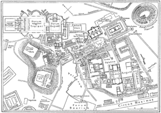
Deutsch: Karte der antiken Innenstadt von Rom |
| തീയതി | |
| സ്രോതസ്സ് | from the Nordisk familjebok (1916), band 23, artikeln "Rom" [1], upload to Swedish wikipedia 23.10.2003 by Den fjättrade ankan |
| സ്രഷ്ടാവ് | ലഭ്യമല്ല |
| മറ്റു പതിപ്പുകൾ | ഈ പ്രമാണത്തിൽ നിന്നും സൃഷ്ടിച്ചവ: Forum Romanum Arcus Augusti.jpg |
അനുമതി
This image was first published in the 1st (1876–1899), 2nd (1904–1926) or 3rd (1923–1937) edition of Nordisk familjebok. The copyrights for that book have expired and this image is in the public domain, because images had no named authors and the book was published more than 70 years ago.
|
This image (or other media file) is in the public domain because its copyright has expired and its author is anonymous.
This applies to the European Union and those countries with a copyright term of 70 years after the work was made available to the public and the author never disclosed their identity. Important: Always mention where the image comes from, as far as possible, and make sure the author never claimed authorship. |
 | |
 |
Note: In Germany and possibly other countries, certain anonymous works published before July 1, 1995 are copyrighted until 70 years after the death of the author. See Übergangsrecht. Please use this template only if the author never claimed authorship or their authorship never became public in any other way. If the work is anonymous or pseudonymous (e.g., published only under a corporate or organization's name), use this template for images published more than 70 years ago.
For a work made available to the public in the United Kingdom, please use Template:PD-UK-unknown instead.
|
യഥാർത്ഥ അപ്ലോഡ് രേഖ
23 oktober 2003 kl.00.39 . . Den fjättrade ankan (Diskussion | Bidrag) . . 1099x777 (209 832 bytes)
പ്രമാണ നാൾവഴി
ഏതെങ്കിലും തീയതി/സമയ കണ്ണിയിൽ ഞെക്കിയാൽ പ്രസ്തുതസമയത്ത് ഈ പ്രമാണം എങ്ങനെയായിരുന്നു എന്നു കാണാം.
| തീയതി/സമയം | ലഘുചിത്രം | അളവുകൾ | ഉപയോക്താവ് | അഭിപ്രായം | |
|---|---|---|---|---|---|
| നിലവിലുള്ളത് | 02:05, 31 ഒക്ടോബർ 2006 | | 1,099 × 777 (74 കെ.ബി.) | Helix84 | Rasterized Image:Map_of_downtown_Rome_during_the_Roman_Empire_large.jpg. ~~~~ Original desc. follows: ---- *{{en|<br> **'''Description''': Map of antique downtown Rome, drawing. **'''Author''': [[:sv:Användare:Den fjättrade ankan|Den fjättrade an |
പ്രമാണത്തിന്റെ ഉപയോഗം
താഴെ കാണുന്ന താളിൽ ഈ ചിത്രം ഉപയോഗിക്കുന്നു:
പ്രമാണത്തിന്റെ ആഗോള ഉപയോഗം
താഴെ കൊടുത്തിരിക്കുന്ന മറ്റ് വിക്കികൾ ഈ പ്രമാണം ഉപയോഗിക്കുന്നു:
- bcl.wikipedia.org സംരംഭത്തിലെ ഉപയോഗം
- be-tarask.wikipedia.org സംരംഭത്തിലെ ഉപയോഗം
- be.wikipedia.org സംരംഭത്തിലെ ഉപയോഗം
- bg.wikipedia.org സംരംഭത്തിലെ ഉപയോഗം
- br.wikipedia.org സംരംഭത്തിലെ ഉപയോഗം
- bs.wikipedia.org സംരംഭത്തിലെ ഉപയോഗം
- ca.wikipedia.org സംരംഭത്തിലെ ഉപയോഗം
- cs.wikipedia.org സംരംഭത്തിലെ ഉപയോഗം
- de.wikipedia.org സംരംഭത്തിലെ ഉപയോഗം
- el.wikipedia.org സംരംഭത്തിലെ ഉപയോഗം
- en.wikipedia.org സംരംഭത്തിലെ ഉപയോഗം
- eo.wikipedia.org സംരംഭത്തിലെ ഉപയോഗം
- es.wikipedia.org സംരംഭത്തിലെ ഉപയോഗം
- et.wikipedia.org സംരംഭത്തിലെ ഉപയോഗം
- eu.wikipedia.org സംരംഭത്തിലെ ഉപയോഗം
- fi.wikipedia.org സംരംഭത്തിലെ ഉപയോഗം
ഈ പ്രമാണത്തിന്റെ കൂടുതൽ ആഗോള ഉപയോഗം കാണുക.