പ്രമാണം:Cold War border changes.png
കൂടുതൽ വ്യക്തതയുള്ള ചിത്രം ലഭ്യമല്ല.
Cold_War_border_changes.png (599 × 436 പിക്സൽ, പ്രമാണത്തിന്റെ വലിപ്പം: 25 കെ.ബി., മൈം തരം: image/png)
| ഈ പ്രമാണം വിക്കിമീഡിയ കോമൺസിൽ നിന്നുള്ളതാണ്. പ്രമാണത്തെക്കുറിച്ചുള്ള വിവരണം താഴെ കൊടുത്തിരിക്കുന്നു.
|
ചുരുക്കം
| വിവരണം |
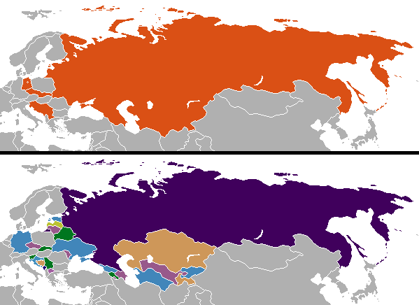
English: Changes in internationally recognized boundaries of countries after the end of the Cold War. Orange in the "before" map represents the territories as of 1991 which were affected. |
| തീയതി | |
| സ്രോതസ്സ് | സ്വന്തം സൃഷ്ടി |
| സ്രഷ്ടാവ് | Aivazovsky (talk) (Uploads) |
അനുമതി
| ഈ സൃഷ്ടി അതിന്റെ സ്രഷ്ടാവായ ഇംഗ്ലീഷ് വിക്കിപീഡിയ പദ്ധതിയിലെ Aivazovsky, സ്വയം പൊതുസഞ്ചയത്തിൽ പ്രസിദ്ധീകരിച്ചിരിക്കുന്നു. ഇത് ആഗോള വ്യാപകമായി ബാധകമാണ്. ചില രാജ്യങ്ങളിൽ ഇത് നിയമപ്രകാരം സാദ്ധ്യമല്ലെന്ന് വന്നേക്കാം; അങ്ങനെയെങ്കിൽ: ഈ സൃഷ്ടി, നിയമപ്രകാരം നിബന്ധനകൾ ഉണ്ടെങ്കിൽ അവയൊഴിച്ച്, യാതൊരു നിബന്ധനകളും ഇല്ലാതെ ഏതൊരാൾക്കും ഏതൊരു ഉപയോഗത്തിനും, ഉപയോഗപ്പെടുത്തുവാൻ Aivazovsky അനുവദിച്ചിരിക്കുന്നു. |
Colored by User:Aivazovsky from public domain Wikimedia Commons source.
യഥാർത്ഥ അപ്ലോഡ് രേഖ
ഈ ചിത്രം ആദ്യം അപ്ലോഡ് ചെയ്തത് ഇവിടെ കാണാം. താഴെയുള്ള എല്ലാ ഉപയോക്തൃനാമവും ഉള്ളത് en.wikipedia സംരംഭത്തിൽ ആണ്.
| തീയതി/സമയം | അളവുകൾ | ഉപയോക്താവ് | അഭിപ്രായം |
|---|---|---|---|
| 2009-12-11 10:57 | 599×436× (15723 bytes) | Ithanyx | Switched to most up-to-date template version. |
| 2008-07-19 07:01 | 599×436× (15610 bytes) | Hoshie | added the last change of the cold war: Kosovo |
| 2007-09-24 04:24 | 599×436× (20607 bytes) | Hoshie | fixed shading on two islands west of the Estonian SSR |
| 2007-02-27 02:21 | 599×436× (15749 bytes) | Aivazovsky | |
| 2006-10-10 06:35 | 599×436× (17502 bytes) | Hoshie | I have updated the map to include Montenegro, the last nation formed out of the cold war. |
| 2006-04-13 01:44 | 602×373× (14138 bytes) | Aivazovsky |
പ്രമാണ നാൾവഴി
ഏതെങ്കിലും തീയതി/സമയ കണ്ണിയിൽ ഞെക്കിയാൽ പ്രസ്തുതസമയത്ത് ഈ പ്രമാണം എങ്ങനെയായിരുന്നു എന്നു കാണാം.
| തീയതി/സമയം | ലഘുചിത്രം | അളവുകൾ | ഉപയോക്താവ് | അഭിപ്രായം | |
|---|---|---|---|---|---|
| നിലവിലുള്ളത് | 01:08, 26 നവംബർ 2023 | | 599 × 436 (25 കെ.ബി.) | Ljutikecap2021 | Reverted to version as of 23:24, 21 June 2023 (UTC) |
| 20:52, 18 സെപ്റ്റംബർ 2023 |  | 599 × 436 (18 കെ.ബി.) | GPinkerton | Reverted to version as of 12:49, 19 March 2023 (UTC) Most of UN member states recognize Kosovo. Reverting pro-Serbian irredentist claims. | |
| 23:24, 21 ജൂൺ 2023 |  | 599 × 436 (25 കെ.ബി.) | Ljutikecap2021 | Reverted to version as of 21:56, 18 March 2023 (UTC) Most countries is nothing, if the UN doesn't recognize Kosovo as independent then it isn't. | |
| 12:49, 19 മാർച്ച് 2023 |  | 599 × 436 (18 കെ.ബി.) | GPinkerton | Reverted to version as of 15:41, 11 January 2023 (UTC) Kosovo is recognized as independent by most countries | |
| 21:56, 18 മാർച്ച് 2023 |  | 599 × 436 (25 കെ.ബി.) | Ljutikecap2021 | If we are going by international recognititon, then Kosovo is Serbia. | |
| 15:41, 11 ജനുവരി 2023 |  | 599 × 436 (18 കെ.ബി.) | GPinkerton | Reverted to version as of 20:15, 17 October 2022 (UTC) The map shows internationally recognized borders not Russian Lebensraum | |
| 14:52, 11 ജനുവരി 2023 |  | 599 × 436 (25 കെ.ബി.) | Ljutikecap2021 | If Kosovo is included, why shouldn't the disputed Russian territories in Eastern Ukraine, Transnistria and Artsakh be included? | |
| 02:59, 26 ഡിസംബർ 2022 |  | 599 × 436 (18 കെ.ബി.) | GPinkerton | Reverted to version as of 20:15, 17 October 2022 (UTC) Undiscussed and unhelpful pro-Russian changes | |
| 21:58, 11 ഡിസംബർ 2022 |  | 599 × 436 (25 കെ.ബി.) | Ljutikecap2021 | New Russian territories, Artsakh and Transnistria added. | |
| 21:08, 4 ഡിസംബർ 2022 |  | 599 × 436 (21 കെ.ബി.) | Savasampion | . |
പ്രമാണത്തിന്റെ ഉപയോഗം
താഴെ കാണുന്ന താളിൽ ഈ ചിത്രം ഉപയോഗിക്കുന്നു:
പ്രമാണത്തിന്റെ ആഗോള ഉപയോഗം
താഴെ കൊടുത്തിരിക്കുന്ന മറ്റ് വിക്കികൾ ഈ പ്രമാണം ഉപയോഗിക്കുന്നു:
- af.wikipedia.org സംരംഭത്തിലെ ഉപയോഗം
- arz.wikipedia.org സംരംഭത്തിലെ ഉപയോഗം
- bn.wikipedia.org സംരംഭത്തിലെ ഉപയോഗം
- ca.wikipedia.org സംരംഭത്തിലെ ഉപയോഗം
- ckb.wikipedia.org സംരംഭത്തിലെ ഉപയോഗം
- cs.wikipedia.org സംരംഭത്തിലെ ഉപയോഗം
- cy.wikipedia.org സംരംഭത്തിലെ ഉപയോഗം
- el.wikipedia.org സംരംഭത്തിലെ ഉപയോഗം
- en.wikipedia.org സംരംഭത്തിലെ ഉപയോഗം
- History of Europe
- Irredentism
- Mikhail Gorbachev
- Nation state
- Nationalism
- Self-determination
- Eastern Bloc
- Secession
- Balkanization
- Cold War
- Revanchism
- Territorial evolution of Russia
- List of irredentist claims or disputes
- Revolutions of 1989
- List of national border changes (1914–present)
- Post–Cold War era
- Dissolution of the Soviet Union
- User:Falcaorib
- en.wikibooks.org സംരംഭത്തിലെ ഉപയോഗം
- es.wikipedia.org സംരംഭത്തിലെ ഉപയോഗം
- hu.wikipedia.org സംരംഭത്തിലെ ഉപയോഗം
- hy.wikipedia.org സംരംഭത്തിലെ ഉപയോഗം
- id.wikipedia.org സംരംഭത്തിലെ ഉപയോഗം
- ja.wikipedia.org സംരംഭത്തിലെ ഉപയോഗം
- kk.wikipedia.org സംരംഭത്തിലെ ഉപയോഗം
- ko.wikipedia.org സംരംഭത്തിലെ ഉപയോഗം
- mk.wikipedia.org സംരംഭത്തിലെ ഉപയോഗം
- pa.wikipedia.org സംരംഭത്തിലെ ഉപയോഗം
- pnb.wikipedia.org സംരംഭത്തിലെ ഉപയോഗം
- pt.wikipedia.org സംരംഭത്തിലെ ഉപയോഗം
- rm.wikipedia.org സംരംഭത്തിലെ ഉപയോഗം
- sl.wikipedia.org സംരംഭത്തിലെ ഉപയോഗം
- sr.wikipedia.org സംരംഭത്തിലെ ഉപയോഗം
- ta.wikipedia.org സംരംഭത്തിലെ ഉപയോഗം
- ur.wikipedia.org സംരംഭത്തിലെ ഉപയോഗം
- zh-classical.wikipedia.org സംരംഭത്തിലെ ഉപയോഗം
- zh.wikipedia.org സംരംഭത്തിലെ ഉപയോഗം
ഈ പ്രമാണത്തിന്റെ കൂടുതൽ ആഗോള ഉപയോഗം കാണുക.