ഗ്രാൻഡ് പോർട്ട് ജില്ല
മൗറീഷ്യസിൽ ദ്വീപിന്റെ കിഴക്ക് ഉള്ള ഒരു ജില്ലയാണ് '''ഗ്രാന്റ് പോർട്ട് (Grand Port).''' ഫ്രെഞ്ചിൽ ഇതിന്റെ അർഥം "വലിയ തുറമുഖം" എന്നാണ്. ജില്ലയുടെ വിസ്തീർണ്ണം 260.3 ച. കി.മീ. ആണ്. 2015 ഡിസംബർ 31ലെ കണക്കെടുപ്പനുസരിച്ച് ജനസംഖ്യ 1,12, 997 ആണ്. [2]
ഗ്രാൻഡ് പോർട്ട് ജില്ല | |
|---|---|
 Sugar cane plantations near Rose Belle | |
 Map of Mauritius island with Grand Port District highlighted | |
| Country | |
| • Chairman | Mr. Ruggoo Yashveer |
| • Vice Chairman | Mr. Seegobin Megduth |
| • ആകെ | 260.3 ച.കി.മീ.(100.5 ച മൈ) |
(2015)[2] | |
| • ആകെ | 112,997 |
| • റാങ്ക് | 5th in Mauritius |
| • ജനസാന്ദ്രത | 430/ച.കി.മീ.(1,100/ച മൈ) |
| സമയമേഖല | UTC+4 (MUT) |
| ISO കോഡ് | MU-GP (Grand Port) |
ചിത്രശാല തിരുത്തുക
-
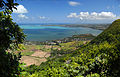 ഗ്രാൻഡ് പോർട്ടിന്റെ മുകളിൽ നിന്നുള്ള കാഴ്ച.
 -
 മൗറീഷ്യസിന്റെ ഗ്രാൻഡ്പോർട്ടിനെ ചിത്രീകരിച്ചികറിച്ചിട്ടുള്ള സ്റ്റാമ്പ്
.jpg)

കുറിപ്പുകൾ തിരുത്തുക
- ↑ "Archived copy". Archived from the original on 4 April 2014. Retrieved 20 October 2013.
{{cite web}}: CS1 maint: archived copy as title (link) - ↑ 2.0 2.1 Ministry of Finance & Economic Development (2016). "ANNUAL DIGEST OF STATISTICS 2015" (PDF). August. Government of Mauritius: 19. Retrieved 23 December 2016.
{{cite journal}}: Cite journal requires|journal=(help)