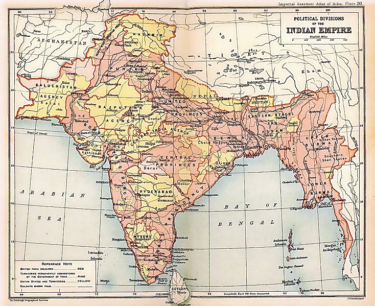
പ്രമാണം:British Indian Empire 1909 Imperial Gazetteer of India.jpg

ഈ പ്രിവ്യൂവിന്റെ വലിപ്പം: 734 × 599 പിക്സലുകൾ. മറ്റ് റെസലൂഷനുകൾ: 294 × 240 പിക്സലുകൾ | 588 × 480 പിക്സലുകൾ | 941 × 768 പിക്സലുകൾ | 1,254 × 1,024 പിക്സലുകൾ | 1,498 × 1,223 പിക്സലുകൾ.
പൂർണ്ണ വലിപ്പം (1,498 × 1,223 പിക്സൽ, പ്രമാണത്തിന്റെ വലിപ്പം: 957 കെ.ബി., മൈം തരം: image/jpeg)
പ്രമാണ നാൾവഴി
ഏതെങ്കിലും തീയതി/സമയ കണ്ണിയിൽ ഞെക്കിയാൽ പ്രസ്തുതസമയത്ത് ഈ പ്രമാണം എങ്ങനെയായിരുന്നു എന്നു കാണാം.
| തീയതി/സമയം | ലഘുചിത്രം | അളവുകൾ | ഉപയോക്താവ് | അഭിപ്രായം | |
|---|---|---|---|---|---|
| നിലവിലുള്ളത് | 20:26, 15 മാർച്ച് 2012 |  | 1,498 × 1,223 (957 കെ.ബി.) | Soerfm | Color |
| 20:28, 15 മാർച്ച് 2012 |  | 1,498 × 1,223 (1.53 എം.ബി.) | Soerfm | Color | |
| 22:55, 8 ഫെബ്രുവരി 2012 |  | 1,498 × 1,223 (957 കെ.ബി.) | M0tty | Remove compression artefacts by a bilateral filtering. | |
| 16:33, 23 മേയ് 2010 |  | 1,498 × 1,223 (694 കെ.ബി.) | Malus Catulus | removed watermark | |
| 23:13, 24 ജൂലൈ 2009 |  | 1,498 × 1,223 (457 കെ.ബി.) | BetacommandBot | move approved by: User:Kintetsubuffalo This image was moved from File:IGI british indian empire1909reduced.jpg {{BotMoveToCommons|en.wikipedia|year=2008|month=October |day=13}} {{Information |Description={{en|Image of map of the British Indian |
പ്രമാണത്തിന്റെ ഉപയോഗം
താഴെ കാണുന്ന 10 താളുകളിൽ ഈ ചിത്രം ഉപയോഗിക്കുന്നു:
പ്രമാണത്തിന്റെ ആഗോള ഉപയോഗം
താഴെ കൊടുത്തിരിക്കുന്ന മറ്റ് വിക്കികൾ ഈ പ്രമാണം ഉപയോഗിക്കുന്നു:
- af.wikipedia.org സംരംഭത്തിലെ ഉപയോഗം
- ar.wikipedia.org സംരംഭത്തിലെ ഉപയോഗം
- arz.wikipedia.org സംരംഭത്തിലെ ഉപയോഗം
- ast.wikipedia.org സംരംഭത്തിലെ ഉപയോഗം
- as.wikipedia.org സംരംഭത്തിലെ ഉപയോഗം
- azb.wikipedia.org സംരംഭത്തിലെ ഉപയോഗം
- az.wikipedia.org സംരംഭത്തിലെ ഉപയോഗം
- ba.wikipedia.org സംരംഭത്തിലെ ഉപയോഗം
- be-tarask.wikipedia.org സംരംഭത്തിലെ ഉപയോഗം
- be.wikipedia.org സംരംഭത്തിലെ ഉപയോഗം
- bg.wikipedia.org സംരംഭത്തിലെ ഉപയോഗം
- bh.wikipedia.org സംരംഭത്തിലെ ഉപയോഗം
- bn.wikipedia.org സംരംഭത്തിലെ ഉപയോഗം
- ca.wikipedia.org സംരംഭത്തിലെ ഉപയോഗം
- ce.wikipedia.org സംരംഭത്തിലെ ഉപയോഗം
- ckb.wikipedia.org സംരംഭത്തിലെ ഉപയോഗം
- cs.wikipedia.org സംരംഭത്തിലെ ഉപയോഗം
- cy.wikipedia.org സംരംഭത്തിലെ ഉപയോഗം
- da.wikipedia.org സംരംഭത്തിലെ ഉപയോഗം
- de.wikipedia.org സംരംഭത്തിലെ ഉപയോഗം
ഈ പ്രമാണത്തിന്റെ കൂടുതൽ ആഗോള ഉപയോഗം കാണുക.
